


mBDL
Description of mBDL
The mBDL application, known as the Mobile Forest Data Bank, is a resource designed for users to access forest maps directly on their smartphones and tablets. This application is available for the Android platform, allowing users to download mBDL and utilize its various functionalities in the field of forestry.
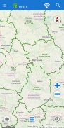
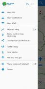
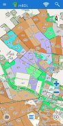
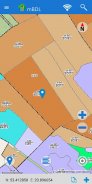
mBDL provides a comprehensive suite of features that cater to individuals interested in forest management and exploration. Users can engage with a range of thematic BDL maps, including basic maps, tree stands, ownership forms, forest habitats, plant communities, hunting maps, tourist development maps, and fire hazard maps. These maps are essential tools for understanding and navigating forested areas.
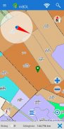
A notable capability of the mBDL application is its area and distance measurement tools. Users can measure specific distances within the maps, which aids in planning and executing forestry activities. Additionally, the app allows users to record GPS locations or mark points identified on the map itself. This feature is particularly useful for forestry professionals who need to document specific locations for future reference.
The application also enables users to record routes and provides simple navigation to various points of interest. Users can save waypoints and routes, which can then be exported as KML files. This functionality allows for seamless sharing of information, as users can send their recorded data to others or import it onto another device that has mBDL installed. Such features enhance collaboration and information sharing among forestry professionals.
Another important aspect of mBDL is its offline functionality. Once the appropriate data is downloaded, users can access it without an internet connection. This is particularly beneficial for those working in remote forest areas where internet access may be limited. The app supports the downloading of maps for forest districts and national parks, ensuring users have the necessary resources at their fingertips even when they are offline.
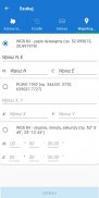
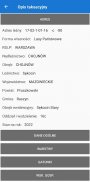
Users can also access a full taxation description for forests of all ownership forms through the mBDL application. This description includes detailed information about the species of trees and shrubs present in a specific area, as well as their economic indications and forest addresses. This feature is invaluable for those involved in forest management and conservation, as it provides essential data for decision-making processes.
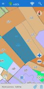
Moreover, mBDL allows users to search for forest divisions efficiently. The app supports searches based on forest addresses, cadastral parcels, or by inputting specific coordinates. This search capability enhances the user experience, making it easier to locate specific areas of interest within the vast forested landscapes.
The application also offers additional layers of information through predefined raster backgrounds. Users can display topographic maps or aerial/satellite orthophotomaps alongside the thematic BDL maps. By integrating these various map types, mBDL provides a more comprehensive view of the terrain and environment, facilitating better planning and navigation.
For those interested in expanding their mapping experience, mBDL allows connections to external WMS services. Users can enter specific URL addresses for any WMS services they wish to utilize, which are then stored within the application for easy access. This feature ensures that users can customize their mapping experience according to their specific needs.
The help menu within the mBDL application includes a manual that outlines the basic functionalities of the app. This resource is beneficial for new users, providing them with the necessary guidance to navigate and utilize the app effectively from the start. Familiarizing oneself with these functionalities can significantly enhance the overall user experience.
The combination of user-friendly features and robust mapping capabilities makes mBDL a valuable tool for anyone involved in forestry or outdoor navigation. The app’s focus on providing critical information and resources directly to users' devices allows for efficient forest management and exploration.
In essence, mBDL serves as a comprehensive tool for accessing and managing forest-related data. Its range of functionalities, from GPS navigation to detailed forestry information, allows users to engage with their environment in a meaningful and informed manner. Whether for professional forestry work or personal exploration, mBDL stands out as a reliable resource for those interested in the natural world.
For more information, you can visit the official declaration of availability: https://www.bdl.lasy.gov.pl/portal/deklaracja-mbdl.
mBDL - Version 2.2.1
(26-03-2025)mBDL - APK Information
APK Version: 2.2.1Package: pl.gov.lasy.bdlLatest Version of mBDL
Other versions


Apps in the same category


